Marcia:
It's been a rough stretch the last 5 or 6 days as we were seemingly lost in the desert on the lonliest road in America. No kidding. That's what it's called.
 And it just about did me in. We did have one Shangri-La campground that popped up out of nowhere like a mirage come true.


And we saw actual mirages of what appeared to be a big gorgeous body of water, until you get to it and it's just white sand. Forever. With a giant dune thrown in for good measure.

Saw a sign for wild horses, but not the critters themselves. Lots and lots of dead cow bones and tumbleweeds. It was tough going for me and naturally much tougher for Tim, but we ended up in beautiful South Lake Tahoe for a lovely restful night in a hotel. I put my back out a few days ago and have been very uncomfortable, so haven't got a whole lot more to tell. I'll let Tim's daily voice messages and the pics below say it for me.
Day 33, 109 miles traveled. Started out in Fallon and fortunately the scenery has changed from desolation to a little more color and certainly a little more urban. I went from Fallon to Carson City on some rolling terrain which was nice. I was fighting some headwinds for awhile but then they relented for a bit. After lunch I went from Genoa, Nevada and crossed over into California, which was obviously a significant milestone for Marcia and me. It felt really good.


From there the climb began up Carson Pass, 22 miles of 3500 feet of elevation gain. I just ground it out and fortunately made it to the top, where Marcia is still struggling with her back and some elevation issues. But it was a relief for us both to make it to that significant and last climb where I will have a major descent tomorrow and only two more days to go.


Marcia: Tim can't help it...he's so good to everyone we meet. This group of older women had driven up Carson Pass by their daughter/granddaughter/neice. Tim and I had just started driving down after his summit and had stopped at this beautiful overlook to Red Lake near the top. When they got out of their car the wind blew a door shut on one of the women's legs and cut her. Tim had the supplies needed in our trusty little vehicle to get her bandaged up. They were so grateful and took our picture overlooking the lake.
Tim:
Day 34 started out with us driving from Lake Tahoe to the top of Carson pass. It was a chilly 38 degrees at the start for a 60+ mile descent down into the valley below. It was interrupted by three or four different paving projects and logging operations as well as a little more than anticipated climbing on the descent.

Had a nice downhill on Fiddletown Road on some more rural roads versus the highways I’ve been on for awhile. We descended into the flats where I jumped onto the American River Bike Trail for about a 25 mile stretch, winding its way through urban suburbs of Sacramento, to finish up the 126 miles for the day in West Sacramento with about 70+ miles tomorrow to go.
Marcia:
Our final day of the ride has arrived. We stayed last night in a slightly sketchy hotel in West Sacramento…it’s hard to tell when you book online what a place actually will be like. We were looking for a pool and hot tub for my back, and it had one. I just hope we didn’t catch anything from using it, but I digress. It was tricky for Tim getting into town from the bike trail with city traffic, and a little stressful getting back on his bike maps this morning, but we are both excited (teary, emotional, but excited) that this adventure is coming to a close. Last night we ate take out on our little patio outside our room, and Tim had found this particularly appropriately named beer to toast his final 100+ mile ride.


This last leg today to San Francisco will be a mere 75ish miles. I know...I know...this is not everyone's normal. I continue to be amazed at Tim's strength of body and mind, and although he may make it look easy, it clearly is not. He is one of the hardest working people I’ve ever met, possessing an incredibly positive mindset and attitude of curiosity and flexibility in his approach to any and all obstacles. Sharing this adventure with him has been a tremendous life lesson for me, which will likely take some time to completely process.
It's been a rough stretch the last 5 or 6 days as we were seemingly lost in the desert on the lonliest road in America. No kidding. That's what it's called.
And we saw actual mirages of what appeared to be a big gorgeous body of water, until you get to it and it's just white sand. Forever. With a giant dune thrown in for good measure.

Saw a sign for wild horses, but not the critters themselves. Lots and lots of dead cow bones and tumbleweeds. It was tough going for me and naturally much tougher for Tim, but we ended up in beautiful South Lake Tahoe for a lovely restful night in a hotel. I put my back out a few days ago and have been very uncomfortable, so haven't got a whole lot more to tell. I'll let Tim's daily voice messages and the pics below say it for me.
Tim:
Day 29 started in Panguich. I climbed up 10,560 feet to the top of Brians’ Head Pass, past Panguich Lake which was a beautiful sight.
 Then I descended down into Cedar City, a nice, fast, 25 mile plus descent down into the valley below. Here we left civilization and ended up on a barren high desert plain, where it’s windy, smoky from the wild fires, and dusty, and on into Milford Utah. The only accommodations were a fairly nice motel, so we got through the day. It was not easy, but with perseverance and teamwork we are 115 miles closer to California.

Day 30 was one of the toughest ones yet. I started out in Milford, travelled 109 miles on a very barren road, passing over four summits, the highest at 7700 feet. Wind was horrific and in the afternoon was probably upwards of 30 miles per hour into my face and side. I go from these summits down into these barren valleys of isolation which was mentally very difficult.

But I did work through it. Marcia did pick me up, and this is the first section where I skipped about 10 miles as I was riding into that 30 mile per hour headwind with all my might to go 7 miles per hour and just couldn’t do it any longer. It was unsafe because the wind was blowing so that I couldn’t hold my line, I couldn’t hear the trucks coming behind me as the sound of the wind roaring in my ears was deafening. We abandoned the ride, found a campground that was just stunning, Cave Lake Campground at the top of this summit where there was a lovely lake that we took a dip in. There were showers, and we had a restful night. The elevation was bothering Marcia, as was her back, so we were a little off. But we continue…
But I did work through it. Marcia did pick me up, and this is the first section where I skipped about 10 miles as I was riding into that 30 mile per hour headwind with all my might to go 7 miles per hour and just couldn’t do it any longer. It was unsafe because the wind was blowing so that I couldn’t hold my line, I couldn’t hear the trucks coming behind me as the sound of the wind roaring in my ears was deafening. We abandoned the ride, found a campground that was just stunning, Cave Lake Campground at the top of this summit where there was a lovely lake that we took a dip in. There were showers, and we had a restful night. The elevation was bothering Marcia, as was her back, so we were a little off. But we continue…
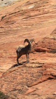
Day 31 was a total of 136 miles traveled. I went up over five summits, with the top being over 7700 feet down into barren, desolate landscape below to climb up again. We ended up at a remote, primitive campsite near some petroglyphs...

Marcia’s back issues prevented her from the short hike to see them, but I was able to get a few pictures. I’m fortunate to be feeling good and glad to get the mileage behind us. The wind has been challenging, but fortitude, perseverance, mental toughness have helped.
Marcia’s back issues prevented her from the short hike to see them, but I was able to get a few pictures. I’m fortunate to be feeling good and glad to get the mileage behind us. The wind has been challenging, but fortitude, perseverance, mental toughness have helped.
Day 32. Marcia’s back has been bothering her and has definitely been causing her a lot of sciatic pain. The bleak, barren landscape does not help for the mental aspects. However, we are forging ahead, 143 miles traveled into a slight headwind all day, up over six lower summits, down to basins, which are just barren desert nothingness on highway 50 through Nevada. Nearing the California border. Well over 3400 miles traveled. Looking forward to ending this journey and getting Marcia home safely.
This sign was on the hotel window at the reservation office when we arrived in Fallon:
Day 33, 109 miles traveled. Started out in Fallon and fortunately the scenery has changed from desolation to a little more color and certainly a little more urban. I went from Fallon to Carson City on some rolling terrain which was nice. I was fighting some headwinds for awhile but then they relented for a bit. After lunch I went from Genoa, Nevada and crossed over into California, which was obviously a significant milestone for Marcia and me. It felt really good.
From there the climb began up Carson Pass, 22 miles of 3500 feet of elevation gain. I just ground it out and fortunately made it to the top, where Marcia is still struggling with her back and some elevation issues. But it was a relief for us both to make it to that significant and last climb where I will have a major descent tomorrow and only two more days to go.
Tim:
Day 34 started out with us driving from Lake Tahoe to the top of Carson pass. It was a chilly 38 degrees at the start for a 60+ mile descent down into the valley below. It was interrupted by three or four different paving projects and logging operations as well as a little more than anticipated climbing on the descent.
Had a nice downhill on Fiddletown Road on some more rural roads versus the highways I’ve been on for awhile. We descended into the flats where I jumped onto the American River Bike Trail for about a 25 mile stretch, winding its way through urban suburbs of Sacramento, to finish up the 126 miles for the day in West Sacramento with about 70+ miles tomorrow to go.
Marcia:
Our final day of the ride has arrived. We stayed last night in a slightly sketchy hotel in West Sacramento…it’s hard to tell when you book online what a place actually will be like. We were looking for a pool and hot tub for my back, and it had one. I just hope we didn’t catch anything from using it, but I digress. It was tricky for Tim getting into town from the bike trail with city traffic, and a little stressful getting back on his bike maps this morning, but we are both excited (teary, emotional, but excited) that this adventure is coming to a close. Last night we ate take out on our little patio outside our room, and Tim had found this particularly appropriately named beer to toast his final 100+ mile ride.
Within minutes from leaving the bustle of Sacramento’s big highway west, I drive on gentle back roads to our designated first rendezvous.

Rolling hills, orchards, cattle, farm stands, dry beige grass everywhere, and the welcome sight of lots of trees. It’s not warm anymore…low 50’s…but it is Saturday, so lots of cyclists and runners are out on the roads this morning. Seems like a happy, healthy, and peaceful place to be. There were hot air balloons in the distance just now…must be a festival of some sort nearby. My back is either a bit better today, or I’m just getting used to the mess that it is and able to put it in the background of life right now. Living in the moment, I pull out my book, enjoy the sounds of the birds and the sunshine beside the road on a beautiful California morning. Our good fortune has been remarkable in so many ways, from the weather the whole trip, to the good people we have met, to safety issues for Tim, and with just a bit more of it, we’ll be in San Francisco by lunchtime.
Tim:
Day 35, the final day. I started out in West Sacramento after finding the bike path I needed to head out on with a couple of rendezvous plans with Marcia. She has been a trouper with her back, supportive to me as I begin the final 70 miles. Some bike paths, some rock slides to navigate around...

...some lovely back roads where I actually ran into a criterium bike race, through vineyards, and we start to emerge into the urban outskirts of San Francisco where we had to adjust our plan because the ferry schedule is too tight for me and doesn’t allow cars for Marcia. So we drove from where the ferry would have taken us across the Oakland Bridge into San Francisco, where I biked the six miles to the Golden Gate bridge through the crazy bike paths of the waterfront parks and over the windy, stunning, Golden Gate Bridge...
 ...where my beautiful wife was waiting for me for the final chapter of the journey.

In total I biked 3757 miles...
 We are safe. It’s been quite the adventure, and I have my wife to thank for it, and our families’ support has meant so much.
...some lovely back roads where I actually ran into a criterium bike race, through vineyards, and we start to emerge into the urban outskirts of San Francisco where we had to adjust our plan because the ferry schedule is too tight for me and doesn’t allow cars for Marcia. So we drove from where the ferry would have taken us across the Oakland Bridge into San Francisco, where I biked the six miles to the Golden Gate bridge through the crazy bike paths of the waterfront parks and over the windy, stunning, Golden Gate Bridge...
In total I biked 3757 miles...
Marcia:
Arrival in San Francisco was a little different than we’d expected given that we were using the bicycle maps in reverse. A six mile ride from the Golden Gate Bridge puts a rider on a ferry to Vallejo, CA and if you are riding east, you are on your way. I went ahead and found the ferry to take us over to the city, only to discover that it is a passenger ferry only. To drive over I needed to go to Oakland, and use the bridge, a one and a half hour drive we weren’t planning on. But after discussing with Tim, we decided to meet in Vallejo near the ferry point, drive over via the Oakland bridge together, and then deposit Tim at the pier where he would have disembarked from the ferry had he taken it. It was so important to him not to miss any miles and keep this trip authentic. San Francisco is a bustling place with more people than it seems possible to fit there. I found my way over the Golden Gate Bridge because we wanted to explore the Marin Headlands and have picnic lunch there. Cycling over it was something Tim wanted to experience and it became our final moment of the trip. An emotional reunion, and the trip was done.


The Marin Headlands...

Celebrating on Pier 39 in San Francisco...I had such an urge to step out and dance with this gentleman as my back was bent in precisely the same posture...


Unfortunately because of my back issues, our camping ended earlier than we'd hoped, and we spent our last few nights in hotels. But I found this picture of our last campsite at sunrise...it captures our memories overall as it was so beautiful there...


The Marin Headlands...
Celebrating on Pier 39 in San Francisco...I had such an urge to step out and dance with this gentleman as my back was bent in precisely the same posture...
The crazy hilly streets of San Francisco .... this picture can't really capture how steep the undulating rises are...
Unfortunately because of my back issues, our camping ended earlier than we'd hoped, and we spent our last few nights in hotels. But I found this picture of our last campsite at sunrise...it captures our memories overall as it was so beautiful there...
I ended up flying home on Sunday, August 26th and Tim is at this moment on day three of a four day drive home. We'd originally planned on shipping the car back and flying home together, but those plans with the shipping company got a little weird and we decided it was safer and much cheaper to drive. I couldn't take another day of sitting in a car, so headed home leaving him to make the trip solo. He is such a good man. Except maybe when he thought it hilarious to take this picture of me at the airport getting ready to be wheeled to my gate. Very funny Shea...
.
In spite of some challenges at the end, this was the trip of a lifetime and an amazing athletic achievement for Tim. Thank you for checking in and sharing it with us. Knowing people we love were keeping track of us, praying for our safe travels, and keeping us in their thoughts was comforting when the going got rough, and a joy for us throughout.
Best sign ever!! After all is said and done, there really is no place like home.